| |
| GIS |
| GPS |
| TRAINING |
| CONSULTING |
| CONTACT |
| CONSULTING |
Established in 2001, Waypoint Mapping has been involved in many exciting projects involving the use of geospatial intelligence and web-based delivery of map data for users at all levels of experience. Recent projects such as the Deepwater Horizon Oil Disaster in the Gulf required a wide range of emerging geospatial technologies including ESRI's ArcGIS Server, ArcGIS Mobile, Trimble GPS mapping, iPhone and iPad apps, satellite and other aerial imagery and satellite-based communications for data posting from remote locations where cell phone-based coverage simply did not exist. Waypoint Mapping's Devon Humphrey served as GIS Unit Leader and Geospatial Intelligence Officer, integrating and implementing these technologies in order to help respond to the crisis. Waypoint Mapping has helped organizations of all sizes establish GIS from scratch by performing needs assessments, designing implementation plans and by providing project management and quality control throughout the entire project life cycle. Often, Waypoint Mapping has been brought in to salvage a failed first attempt at GIS by organizations that know things can be done better. Whether a GIS Jump Start or GIS Tune Up are in order, Waypoint Mapping can apply expert knowledge and project experience in order to make sure that the project is completed on time and within budget. Waypoint Mapping is based in Austin, TX and provides consulting services world-wide. |

GIS System Design at the Deepwater Horizon
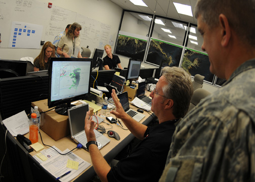
Comparing NGA satellite imagery with aerial overflight data at the Deepwater Horizon

Realtime weather for GIS